SOLD
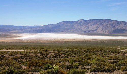
small Spring
40 acres nevada desert
 with small Mountain

- SIZE: 40+/- acres
- APN#: 7-330-05
- LEGAL DESCRIPTION: Township 4N, Range 33E, Section 31, SE4SE4
- STATE: Nevada
- COUNTY: Mineral
- GENERAL LOCATION: 29 miles SE of Hawthorne. Southern Mineral county
- DRIVING DIRECTIONS: about 6 miles off of Hiway 360 to the west
- GPS (approx. ): NW: 38.15561 , -118.34963 ; NE: 38.15553 , -118.34495 ; SE: 38.15179 , -118.34511 ; SW: 38.15191 , -118.34996 ***** Turn off of Hiway 360: 38.105497 ; -118.275549 ** Crossroads I : 38.142359 , -118.291560 : * Crossroads II: 38.14891 , -118.324579:
- GENERAL ELEVATION: 5150-5330 ft.
- GENERAL INFORMATION: Surrounded by BLM lands. small Spring on property.
Views for miles. Remote. BLM road to and through property. BLM/NFS/gov't
Topo maps show small spring named "Community Spring"
- TYPE OF TERRAIN: Varied . level, rolling, sloped, steep
- ZONING:
- POWER: No
- PHONE: No
- WATER: no. would need to iinstall well or holding tank.
- SEWER: No. Only needed when/if you build.
- ROADS: dirt
- PROPERTY TAX: $88 a year
- CLOSING/DOC. FEES: $90.
- TIME LIMIT TO BUILD: none
- ASSOCIATION DUES: none
- TITLE INFORMATION: Free and clear
- Outside Info Links: Toiyabe
national Forest
- AREA INFO: outside Link
- Owner financing available.
No Qualifying. No Credit Checks.Gps/lats/longs coordinates are provided as a tool to assist the Buyer.
Use the maps to confirm.
BUYER TO VERIFY listings' GPS coordinates
- FINANCING
INFO and PURCHASE
INFO
conversion chart land area. sq. ft. acres, hectacres, miles, etc
c: 1881.com
questions??? please email
or call us
512-478-9999
Link to Weather Underground . Historical Data &
Forecasts