STEMPLE
PASS
STEMPLE
PASS
MONTANASTEMPLE
PASS
15 miles from Lincoln and 30 miles from Helena, These parcels have it all including hunting for elk, deer, bear, mountain lion and upland game birds. All 9 claims have excellent building sites, some are on the top of a mountain with 360° views. Easily accessible 3 seasons of the year and with snowmobiles in the winter. Just 15 miles south of the top of Stemple Pass about 30 miles from Helena, MT. and 18 miles from Lincoln, Mt.
The land is almost completely surrounded by Forest Service ground.
The views are spectacular; you can see Red Mountain in the Bob Marshall Wilderness,
the Mission Mountain Range, the lights of Helena and Lincoln at night. Just
west of the Continental Divide, Lincoln is located on Highway 200, 80 miles
east of Missoula and 86 miles west of Great Falls. Helena is 60 miles to the
southwest. Just west of the Continental Divide, Lincoln is the perfect stop-over
when traveling between Yellowstone and Glacier National Parks.
Nestled in the Rocky Mountains, Stemple
Pass is bordered by the spectacular Bob Marshall and Scapegoat Wilderness
areas to the north and the sparkling Blackfoot River to the south. Stemple Pass
at 6,376 feet on the southern rim of the Blackfoot Valley.
Located in west-central Montana, the Helena National Forest surrounds Montana’s Capital City and offers close to one million acres of distinctive landscapes. The Forest is administered by District headquarters in Lincoln, Helena, and Townsend, with the Supervisor’s Office also located in Helena. (click here for map)
Straddling the Continental Divide, the Helena National Forest is rich with natural and cultural resources (see Forest Resources link). Its diverse topography and geology provides wonderful scenery and many recreational opportunities. The Forest's mountain ranges contain a wide diversity of plant and animal life. Native cutthroat trout and other fish species populate clear mountain lakes and streams. Evidence of past human use, ranging from ancient Indian cliff paintings to historic mining ruins, is everywhere.
More Pics 1 More Pics 2 More pics 3 More Pics 4
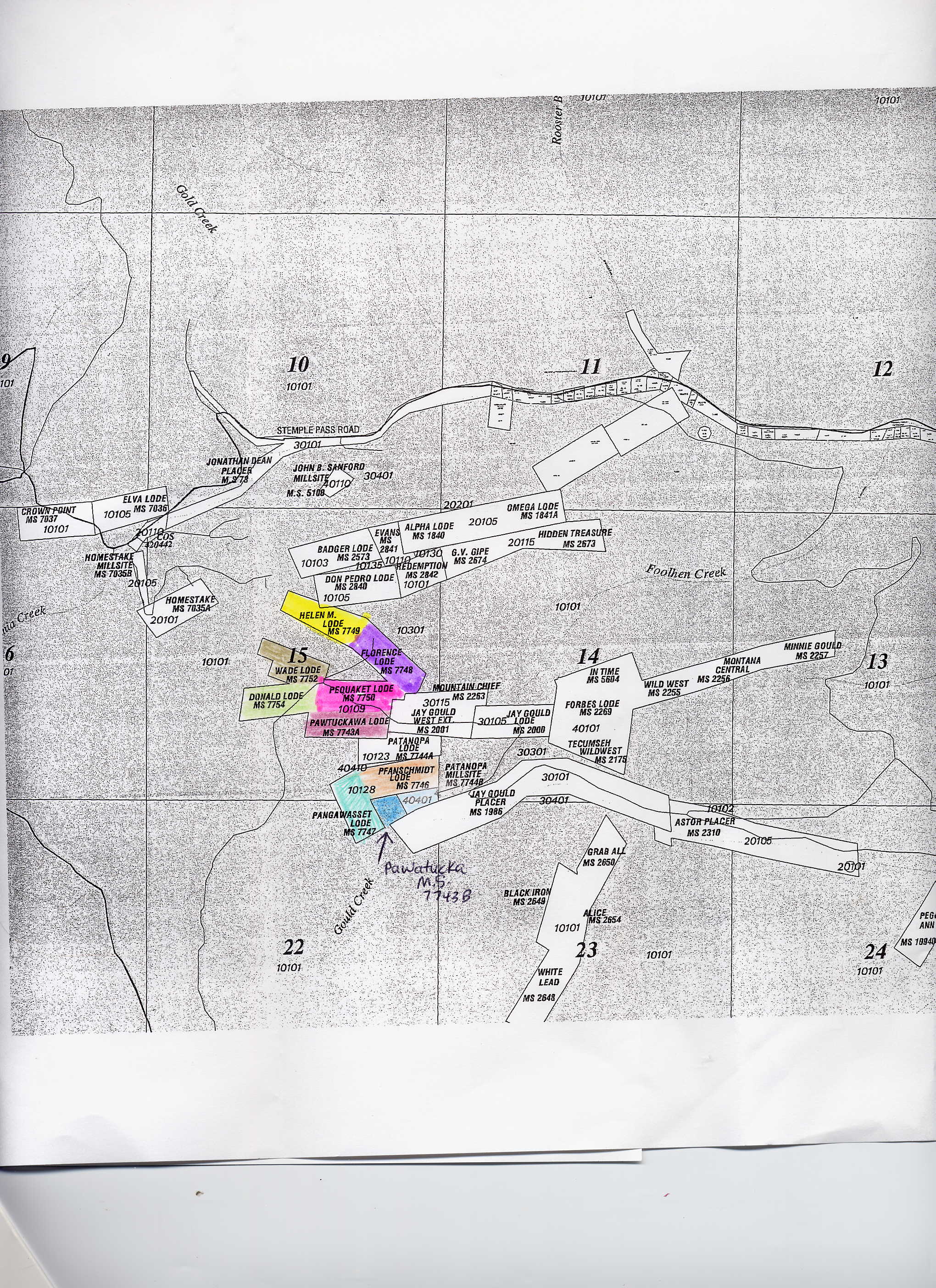
| Name | MS# | acres +/- | Notes | $$$ |
| Pawtuckawa | 7743A | 20 | Borders Pequaket. 1 side borders Forest service | 79,000 SOLD |
| Pawtuckawa Mill site | 7743 B | 5.0 | Has mine tunnel opening. Borders Pfanschmidt and Pannawaset | 50,000 |
| Florence | 7748 | 18 | Borders Forest Service on 3 sides and Helen M. | 89,000 |
| Helen M. | 7749 | 16 | Borders Forest Service on 3 sides and Florence | 89,000 |
| Pequaket | 7750 | 16 | Borders Forest Service on 1 side. Borders Donald and | 79,000 SOLD |
| Wade | 7752 | 15 | Borders Forest service on 3 sides. Borders Donald & Pawtuckana | 90,000 |
| Donald | 7754 | 16 | Borders Forest Service | 95,000 SOLD |
| Pfanschmidt | 7746 | 18.6 | Borders Forest service 1 side. Borders Pannawaset & Pawtuckana Mill site | 65,000 |
| Pangawaset | 7747 | 18.0 | Borders Forest Service 1 side. Borders Pfanschmidt & Pawtuckana Mill site | 65,000 SOLD |